


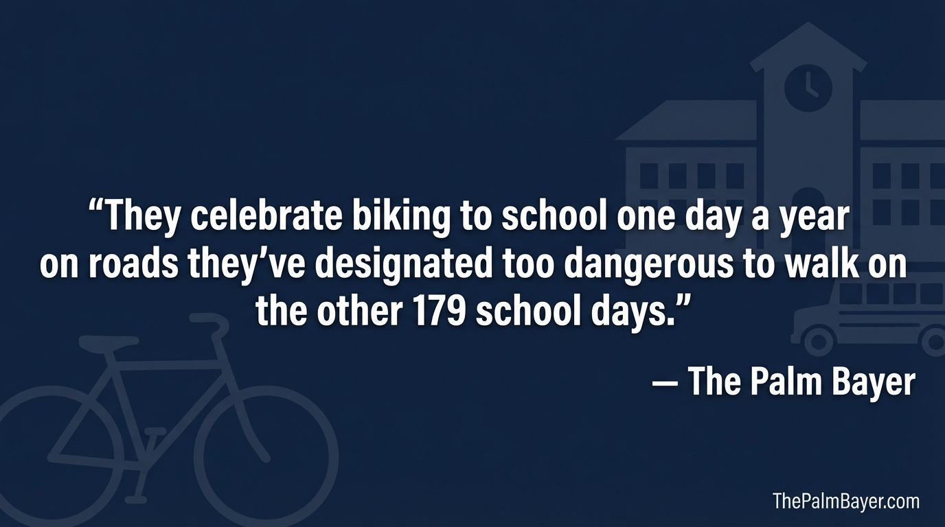
Palm Bay, FL -- On May 6, the Space Coast Transportation Planning Organization will celebrate Bike & Roll to School Day. Schools across Brevard County are invited to participate. Kids ride their bikes, parents cheer, everyone posts photos.
They celebrate biking to school one day a year on roads they've designated too dangerous to walk on the other 179.
That is not a rhetorical flourish. It is what the FOIA records show
.
The Records Brevard Public Schools Doesn't Advertise
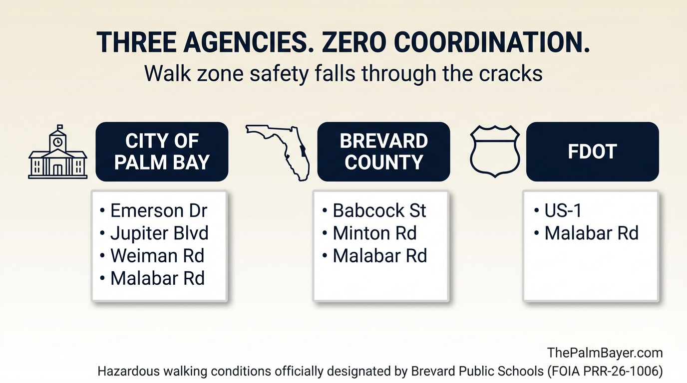
A public records request filed April 6 with Brevard Public Schools produced a document the district has never published: a list of official hazardous walking condition designations for Palm Bay elementary schools.
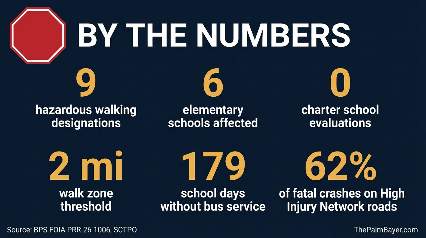
The list has nine entries across six schools.
Jupiter Elementary (2): Malabar Road crossing; Jupiter Boulevard walking condition
Lockmar Elementary (2): Minton Road/Emerson Drive crossing and walking condition; Emerson Drive east side, Brisbane to Boeing
McAuliffe Elementary (1): Jupiter Boulevard near Canal 21
Palm Bay Elementary (1): US 1 at Palm Bay Road
Port Malabar Elementary (1): Malabar Road at Babcock Street
Sunrise Elementary (2): Babcock/Ramblebrook crossing; Weiman Road to Babcock walking condition
These are not informal complaints. They are formal district determinations, filed under Florida Statute 1006.23, acknowledging that the routes elementary students are expected to walk present conditions hazardous enough to trigger legal obligations.
Nobody publicized this list. There is no map on the BPS website. There is no notice on school homepages. Parents who don't know to file a public records request have no way to know their child's walk route has been officially flagged.
What the Statute Actually Says
Florida Statute 1006.23 sets measurable thresholds. A walking route is hazardous when there is no four-foot-wide walkable area adjacent to the road. On uncurbed roads posted at 50 mph or higher, the walkway must be set back at least three feet from the road edge. Any road with six or more lanes is automatically hazardous at uncontrolled crossings, regardless of speed. High-traffic uncontrolled crossings (over 360 vehicles per hour per direction) qualify as well.
When a route meets those thresholds and the determination is formalized, the school district must provide transportation to students who would otherwise walk it. The state has a dedicated funding category to cover the cost of busing students on hazardous routes.
There is a critical scope limit: the statute applies to grades K through 6 only. Seventh through twelfth graders on the same roads get no statutory protection. The law creates a floor for elementary school children. It does not cover the rest.
The process is complaint-driven. A 2022 report by the Florida Office of Program Policy Analysis and Government Accountability reviewed 55 of 67 Florida school districts and found not one proactively evaluates walking routes. Every district, including Brevard, waits for someone to complain. Parents must know the law exists, know how to file, and actually do it. Families who don't know can't benefit.
Brevard does not publish its hazardous designation list. This FOIA response is what that list looks like.
A Funding Rule Dressed as a Safety Standard
The 2-mile walk zone is not a safety determination. It is a funding rule.
Florida Administrative Code Rule 6A-3.001 defines "reasonable walking distance" as no more than two miles between home and school, or 1.5 miles between home and the assigned bus stop. Florida Statute 1011.68 operationalizes it: districts only receive state transportation funding for students living beyond that threshold. Students within two miles of school cost the district money to transport, with no state reimbursement.
Brevard County School Board Policy 8660 adopts the two-mile standard. So does every major Florida school district researched. Broward uses two miles. Miami-Dade uses two miles. Orange, Hillsborough, Lee. All of them. The reason is simple: transporting walk-zone students comes entirely out of local funds.
The state built a financial incentive that puts children on arterial roads. Every district follows it because they can't afford not to.
This year, Florida House Bill 1213 proposed a pilot program to evaluate a one-mile threshold for all K-12 students, along with hazardous condition coverage for grades 7 through 12. The House passed it unanimously, 114-0, on April 24, 2025. The Senate killed it.
The two-mile rule remains. The financial structure remains. The roads remain.
Palm Bay Is Spending Millions to Fix a Problem It Didn't Create
In September 2024, the City of Palm Bay received a $2.4 million federal grant through the Safe Streets and Roads for All program. The project: a six-foot sidewalk along the east side of Emerson Drive, a pedestrian hybrid beacon, removal of one merge lane, and crosswalks equipped with rectangular rapid-flashing beacons.
Look at the FOIA list. Hazard #080037 and Hazard #260001 both designate Emerson Drive conditions near Lockmar Elementary as hazardous. The city is spending federal money on a corridor that BPS has already officially declared dangerous for children to walk.
The Space Coast TPO spearheaded that grant application using High Injury Network data and its own School Routes Analysis findings. The Minton Road and Emerson Drive intersection averaged 53 crashes per year between 2013 and 2017, making it the third most dangerous intersection in Brevard County during that period. The city has also approved a $67,948 contract to redesign signals at Emerson Drive and St. Johns Heritage Parkway. Lockmar Estates road paving, serving the neighborhood surrounding the Emerson Drive corridor, is in design at an estimated $8.6 million.
Mayor Rob Medina, announcing the federal grant last September: "This project underscores Palm Bay's commitment to creating a safer, more pedestrian-friendly community."
The city is spending millions of dollars to correct an infrastructure gap that exists because the school board's walk zone policy sends elementary children onto those roads. The school board creates the demand. The city absorbs the cost. Neither entity has been required to explain the arrangement publicly.
Vision Zero on Paper, Walk Zones in Practice
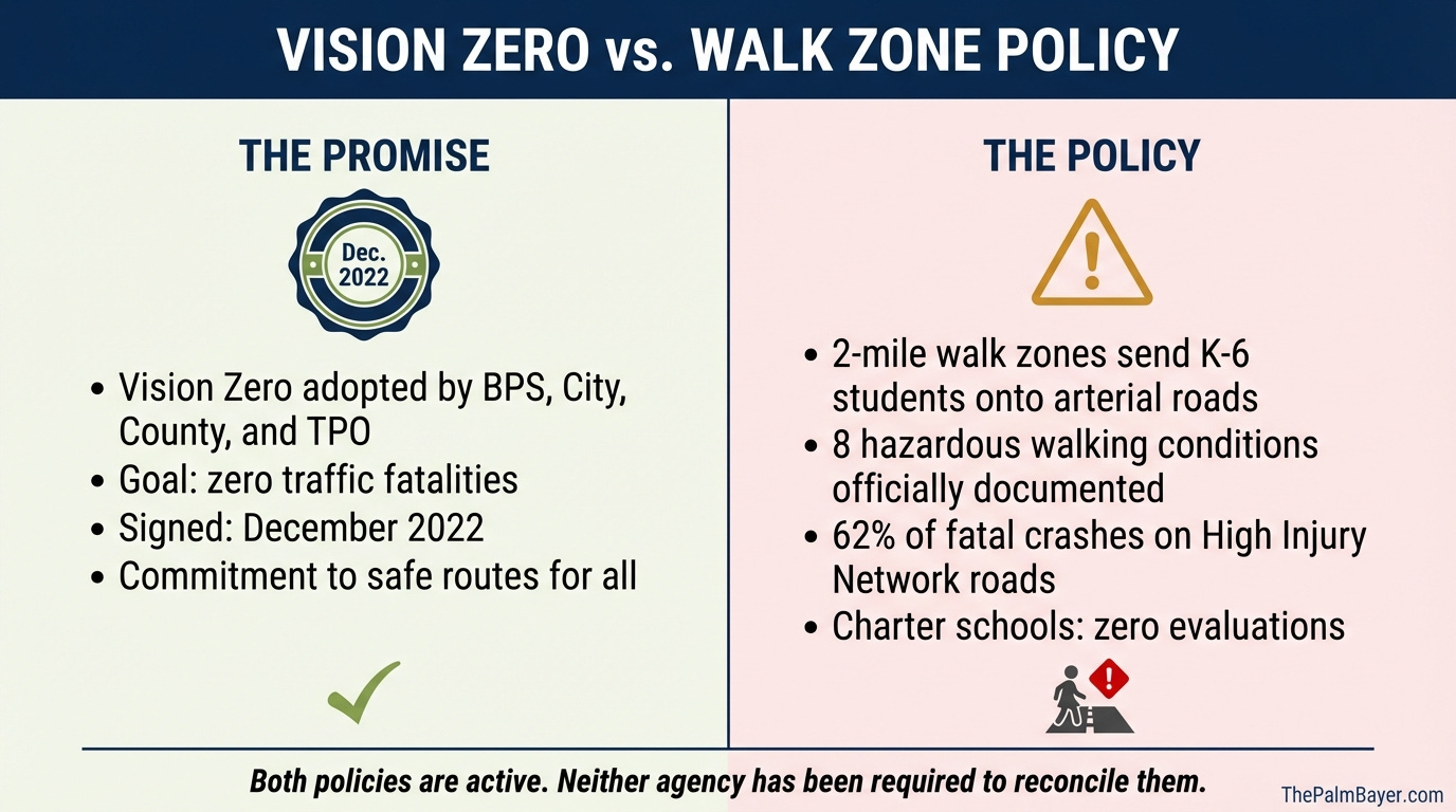
In July 2019, the Space Coast TPO Governing Board adopted Resolution #20-02, committing to Vision Zero: zero traffic fatalities and serious injuries on Brevard roadways. By December 2022, municipalities across Brevard County had adopted the resolution. Brevard County government adopted it. Brevard Public Schools adopted it.
Palm Bay's 2045 Comprehensive Plan includes it at Policy TE-1.6: the city shall "advance the Vision Zero strategy in designing and planning the transportation system in the City."
Vision Zero's foundational principle is that traffic fatalities and serious injuries are preventable. The same school district that signed that commitment operates a walk zone policy placing elementary students on corridors the Space Coast TPO has documented as part of the High Injury Network. That network accounts for 62 percent of all fatal crashes and 25 percent of all serious injury crashes in Brevard County.
The Space Coast ranked third in the nation for pedestrian and bicyclist fatalities per 100,000 residents in 2019. In 2022, the Palm Bay-Melbourne-Titusville metro ranked 12th most dangerous nationally for pedestrian fatalities. In 2024, Brevard County recorded 82 traffic fatalities; 37 percent involved vulnerable road users: motorcyclists, pedestrians, bicyclists.
A pedestrian struck at 40 mph has roughly a 10 to 15 percent chance of survival. Florida drivers admit it: 38 percent told AAA they had exceeded the speed limit in an active school zone.
The BPS Vision Zero resolution commits to the goal of zero deaths. The walk zone policy is what puts children in the path of the problem. These two positions cannot coexist indefinitely without someone being asked to reconcile them.
The Charter School Gap
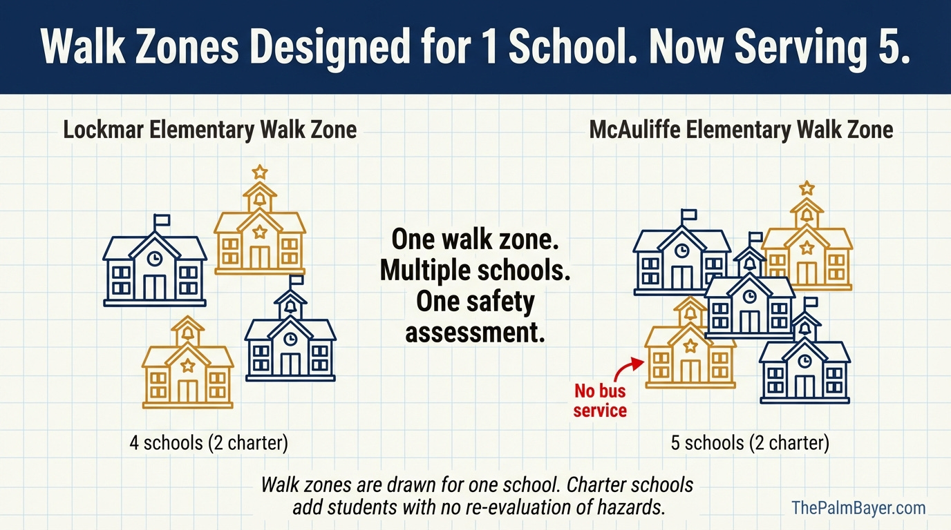
The nine hazardous designations in the FOIA response cover six traditional public elementary schools. The count for charter schools: zero.
This is not because charter school traffic is less dangerous. It is because charter schools sit entirely outside the F.S. 1006.23 framework.
Pineapple Cove Classical Academy operates its K-8 campus at 720 Emerson Drive NE, on the same corridor where BPS has designated multiple hazardous walking conditions for Lockmar Elementary. PCCA has no district bus service. Parents drive. The result has been documented since at least August 2022, when a Change.org petition with 249 signatures demanded the school build a proper drop-off loop. As of April 2024, Spectrum News and MyNews13 documented more than 100 cars stacking on Nesbitt Street, stretching half a mile. Parents arrived up to an hour before dismissal. When the school implemented staggered release times to reduce congestion, the congestion window extended from 20 minutes to more than an hour and a half.
Residents Darin Varner and Ron Cook told Spectrum News in April 2024 that the roads were impossible to navigate. "The roads are blocked. It's still hard to get through," Varner said. "It's a nightmare, it really is," Cook said.
City PIO Christina Born confirmed at the time that the city had been working with police, public works, and the school on the issue, and had requested PCCA "explore busing options." The city also noted the school has no code violations: the car loop routes use public streets, and the city has no legal mechanism to compel PCCA to change that without a conditional use permit condition.
The city secured $2.4 million in federal funds for pedestrian safety improvements on Emerson Drive, the same corridor where BPS has designated multiple hazardous walking conditions. It has also approved a $67,948 contract to redesign signals at Emerson Drive and St. Johns Heritage Parkway.
PCCA's planned high school expansion on the opposite side of Emerson Drive is conditioned, according to press reporting, on modifying the pickup route before the city will approve construction. That condition exists because the city's only leverage over a charter school's traffic is the permitting process. It is not enough.
The F.S. 1006.23 framework, which requires joint inspections and formal hazardous determinations, does not apply to charter schools at all. No statute requires BPS to evaluate walk zone safety conditions around charter school sites. No statute requires charter schools to provide transportation, or to be included in district School Route Analyses conducted by the TPO. The city engineers around their traffic impact. Nobody has evaluated whether the children navigating that traffic are in a legally hazardous walking condition. Because nobody is required to.
This is the gap: charter schools are sited within existing walk zones, generate concentrated car traffic on corridors already used by elementary walkers, receive no hazardous route evaluation, and the city absorbs the infrastructure cost regardless. There is a three-way mismatch of authority, obligation, and cost. The city has no seat at the BPS table and no seat at the charter school table. It has the bill.
The Governance Catch-22
Here is how the statute is supposed to work: the district superintendent requests a joint inspection involving school, government, and police representatives. If the team determines a hazard exists, the school board issues a formal correction request to the responsible road authority. The city or county, as road owner, must correct the condition. Until it does, BPS must bus the students.
Here is how it works in Palm Bay: the nine designations in the FOIA response exist. Whether BPS has formally notified the city of those designations, and whether the city has received a correction request for any of them, is not yet confirmed.
What is confirmed: the city is building infrastructure on the same corridors BPS has designated hazardous, without having been formally triggered to do so under the statute. Either the city is correcting hazards before BPS has requested correction, or the two agencies are operating on parallel tracks with no formal coordination. Both interpretations are a problem.
Under F.S. 1006.23, if a route is formally declared hazardous, BPS must bus students until the hazard is corrected. Right now, it appears BPS has formal hazardous designations on record and the city has no knowledge of formal correction requests being filed. The statute's remedy exists. It is not being invoked. The children are still walking.
What Taxpayers Are Actually Paying For
The school district's ability to offload walk zone safety infrastructure onto the city is compounded by a funding disparity most taxpayers never see on their TRIM notice.
Brevard Public Schools is exempt from Florida's Save Our Homes 3 percent annual cap on assessed value increases. The Florida Constitution, Article VII, Section 4(c), makes the exemption explicit: the cap "does not apply to school taxes."
Florida homeowners get two homestead exemptions: the first $25,000 and a second $25,000 that applies between $50,000 and $75,000 of assessed value. That second exemption reduces city and county taxes, but it does not apply to school taxes. BPS collects on a higher taxable value than the city or county does on the same property.
Here is what that looks like on a typical Palm Bay home purchased in 2016 for $200,000 and now worth approximately $380,000. The city's taxable value is capped by Save Our Homes. After nine years of 3 percent annual increases and both homestead exemptions, the city taxes on roughly $211,000. BPS is not capped. It taxes on the full market value minus only the first $25,000 exemption: $355,000. At the 2025 millage rates (BPS: 6.31 mills; City of Palm Bay: 7.70 mills per the BCPAO tax roll), that homeowner pays approximately $2,240 to BPS and $1,624 to the city. More to the school district, on a higher taxable value, at a lower millage rate.
BPS collects those taxes countywide. For FY2025, BPS ad valorem revenue across all funds was approximately $461 million. The City of Palm Bay's total property tax revenue for FY2025 was $57.8 million. The school district collects roughly eight times what the city collects.
BPS then uses the walk zone policy to defer transportation infrastructure costs: sidewalks, crosswalks, traffic signals, pedestrian beacons. Those costs land on the city, the county, and federal grantors. The entity with the most money and fewest revenue restrictions created the infrastructure demand and offloaded the cost to the lower-funded entities constrained by the cap it is exempt from.
This is not an accusation. It is the arithmetic of the arrangement.
What Needs to Happen
The problems here have solutions. None of them require waiting for the state legislature.
BPS should formally notify the City of Palm Bay of the nine existing hazardous walking condition designations and initiate the correction request process for corridors that haven't been corrected. Families with elementary students on those routes should be receiving Category G transportation now, not after the next complaint.
BPS should evaluate charter school sites under the same F.S. 1006.23 framework used for traditional schools. The statute does not require this; nothing prevents it. PCCA Lockmar sits on a corridor BPS has already designated hazardous for Lockmar Elementary students. The charter school sits on the same road. The children are the same age. The cars are the same cars.
The Space Coast TPO should include charter school traffic in its School Route Analyses. The current program assesses traditional school walk zones. Charter schools draw from across the district, generate concentrated traffic, and their routes have never been formally assessed. The data gap is real. The program should fill it.
The City of Palm Bay, BPS, and the TPO should build a single GIS layer. Right now, BPS tracks its hazardous designations in a document that took a FOIA request to surface. Charter school routes are not tracked at all. The city builds infrastructure without a complete picture of where the hazards are or which schools have been evaluated. The data exists in pieces across three agencies. A unified map showing all schools, all walk zones, all hazardous designations, all sidewalk gaps, and current traffic counts would cost less than one traffic signal. The city is making eight-figure infrastructure decisions without it.
The Florida legislature should amend F.S. 1006.23 to include charter schools and require proactive route evaluation. HB 1213 was a start and the House passed it unanimously. The Senate killed it. The argument for a one-mile threshold did not disappear because one chamber declined to act.
The Bike & Roll to School Day event is real, and it is a good thing. Kids should ride bikes to school. The TPO and the schools that participate are doing something worth celebrating.
The other 179 school days are the story.
Sources
Brevard Public Schools FOIA Response PRR-26-1006-Gaume (April 6, 2026)
Florida Administrative Code Rule 6A-3.001 — Reasonable Walking Distance
HB 1213 (2025) — K-12 School Route Optimization Pilot Program (passed House 114-0; died in Senate)
Palm Bay 2045 Comprehensive Plan, Policy TE-1.6 (Vision Zero)
Palm Bay Secures $2.4M Federal Grant for Pedestrian Safety on Emerson Drive — The Palm Bayer, September 2024
PCCA Traffic Congestion on Palm Bay Streets — Spectrum News / MyNews13, April 30, 2024
Change.org Petition: Pineapple Cove Lockmar Needs to Build a Drop-off Loop (August 2022, 249 signatures)
Palm Bay Halts School Zone Speed Camera Program — The Palm Bayer
Space Coast Ranked 12th Most Dangerous Metro for Pedestrians (2022 Report) — Space Coast Daily
OPPAGA Report: School District Transportation Hazardous Conditions (2022)
